Showing posts with label Dams. Show all posts

Tuesday, April 19, 2011

Mandohol


Mandohol

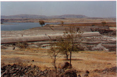
Mandohol Medium Project (Earthen Dam) is constructed across Mandohol river at village Karjule Harya, Taluka- Parner, District- Ahmednagar in between 1977 to 1983. The irrigation was started since 1984.
The catchment area of this project is 142.45 Sq.km (54.96 Sq.miles). The length of this dam is 510 m. & height is 26 m. Gross storage capacity of this dam is 11.30 Mcum (399 Mcft.). There is a Right Bank Canal, 26 km. in length, irrigating an area of 2266 ha. The total expenditure incurred on this project is Rs. 362.00 Lakhs.
There is considerable leakage from the canal of this project, as it passes through hilly & rocky area. An administrative approval has been accorded for Rs. 346.57 Lakhs vide GR No. S-95 / 212/89 IM(Works) dtd. 24.11.94, for laying the PVC Reblock pipes in the canal. As per Govt. instruction, an alternate proposal is submitted to Govt. of Rs. 1721.12 Lakhs, in which PSC pipes are to lay in canal. It is also instructed to the Division office to study a economical proposal. The budget grant for 2003-04 is Rs. 5.00 Lakhs & total expenditure incurred upto June 2003 is Rs. 0.75 Lakhs.

Mandohol Dam

Mula


Mula

Mula dam is constructed across Mula river at Baregaon Nandur, Taluka - Rahuri, District- Ahmednagar in 1971, situated at 35 km. from Ahmednagar.
History:
 In 1957, construction of masonry dam across Mula river, at Wanjarwadi, Taluka - Rahuri, having capacity of 22250 Mcft, was sanctioned. But due to the problem of deep foundation & river diversion, the place of the dam was changed downwards to Baregaon Nandur, Taluka - Rahuri. Government sanctioned an earthen dam having storage capacity of 26000 Mcft.
Project: 
The construction of a dam is completed in between 1966 to 1971. This project consists of a Mula Right Bank Canal, 52 km in length & Mula Left Bank Canal 18 km. in length, irrigating 80810 ha. of Rahuri, Newasa, Shevgaon & Pathardi talukas of Ahmednagar district.
The irrigation on this project was started from 1972. The designed discharge at the head of Mula Right Bank Canal is 1650 cusecs, irrigating 70689 ha. by this canal. Branch I & Branch II are offtaking from Mula Right Bank Canal. The designed discharge at the head of Mula Left Bank Canal is 250 cusecs, irrigating 10121 ha. by this canal.
Mula High Level Right Bank Pipe Canal (Wambori Pipe Chari) & Mula High Level Left Bank Pipe Canal (Bhagda Pipe Chari), a part of Mula Project, are sanctioned & work of these canals are in progress. 161 Bandhares & Percolation tanks are to be filled by these canals, irrigating an area of 3568 ha. & 250 ha. (indirectly) respectively. The details of these canals are given separately in the On-going Projects topic.


Adhala


Adhala

Adhala Medium Project (Earthen Dam) is constructed across Adhala river, a tributory of Pravara at village Adhala, Taluka- Akole, District- Ahmednagar in 1970 to 1977. The irrigation was started since 1978.
The catchment area of this project is 177.11 Sq.km (68.33 Sq.miles). The length of this dam is 623 m. & height is 40 m. Gross storage capacity of this dam is 30.00 Mcum (1066 Mcft.). There are two canals, viz. a Right Bank Canal, 12 km. in length, irrigating an area of 2422 ha. & a Left Bank Canal, 9 km. in length, irrigating an area of 1491 ha. totaling to 3914 ha. An administrative cost of this project is Rs. 256.00 Lakh & the expenditure incurred was Rs. 218.14 Lakhs
An Administrative approval for the modernisation of Canals & distribution system of Adhala Medium Project is accorded vide. Govt. Resolution No. S -95/351/88 IM (Works) dtd. 269.9.1997 for Rs. 198.50 Lakhs. The budget grant for 2003-04 is Rs. 3.00 Lakhs & total expenditure incurred upto June 2003 is Rs. 0.13 Lakhs.

Adhala Dam


Bhandardara


Bhandardara

Bhandardara dam (Wilson Dam) is constructed across Pravara river at Bhandaradara village, Taluka Akole, District Ahmednagar in between 1910 to 1926.
History:
Prior to construction of Bhandardara dam, pick-up weirs for irrigation purpose were constructed across Pravara river @ Lakh, Taluka- Shrirampur, District- Ahmednagar in 1869 & @ Ozar, Tal. Sangamner in 1893 There is a Left Bank Canal to Lakh Pick-up weir & Pravara Left Bank & Pravara Right Bank canal to Ozar weir.
Lack of perennial flow in the river resulted in to shortage of water for irrigation. Hence, it became necessary to construct a dam across Pravara river. Originally, an earthen dam across Pravara river @ Mhaladevi, Taluka- Akole was sanctioned in 1882. This proposal was dropped due to technical problem. In 1889, it was proposed to construct a masonry dam at Samrad, Taluka- Akole. This scheme was also left due to less storage capacity. In 1985, at the time of famine construction of dam @ Mhaladevi was taken again. There was technical problem in footing & hence the scheme was finally dropped in 1902. Afterwards, two alternatives i.e. construction of masonry weirs at Randha & Iswarde were studied. It was finally proposed to construct a masonry dam at Iswarde. The name of the nearby village Bhandardara was given to the dam constructed at Iswarde.
Project:
The construction of a dam at Bhandaradara envisages height 250-ft. & costing Rs. 70.86 Lakhs was proposed in 1907. This dam was highest dam over that time in India.
The catchment area of this dam is 122 Sq. km. (47 Sq.miles). This dam consists of an ungated spillway of 198 m. (650 ft.). The automatic radial gates adjacent to the ungated spillway, controls the dam storage of 313 Mcum.(11039 Mcft). There are outlets to the dam at 50 ft., 100 ft, 150 ft. 200 ft. in height from river bed.
The dam was strengthened after the earthquake that took place at Koyna, District- Satara in 1967. The water is released in river from outlets of the dam & supplied for irrigation & non-irrigation (Drinking & Industrial purpose) purpose through Pravara Left Bank & Pravara Right bank Canal offtaking from Ozar weir situated 85 kms. downstream from Bhandardara dam. The length of the Pravara Left Bank Canal is 77 km. irrigating 14577 ha. area & the length of Pravara Right Bank Canal is 45 km. irrigating 8500 ha. area totaling to 23077 ha.
Hydro electricity is generated since June 2001, from Bhandaradara Hydroelectric Project Phase I (12 MWatt) & Bhandaradara Hydro-electric Project Phase II (34 MWatt), from the water released from dam. The electricity generated since August 2001 from Bhandaradara Hydroelectric Project Phase I is appended.


Next Generation IT Solutions